To download data, you must first create an account with us. This only takes a few moments and can be accomplished by
filling out the signup form below.
Create a New Account
Time period covered by the CloudSat mission
The CPR began collecting research data on June 2, 2006, and the science mission ended on December 20, 2023.
Through the years, a number of changes to radar operations have occurred that users should keep in mind, and there
are several multi-month periods where the radar was not operating. The next section highlights some of these
important dates.
Important dates and things to keep in mind
Between 2006 and the present, a number of changes have occurred to the operation of the radar. Key dates when these
changes occur are used to divide the mission into a number of epochs; see below for a comprehensive list.
Probably the most important change is the use of Daylight-Only Operations (DO-Op) since October 27,
2011.
Some of the most important dates to keep in mind:
2011-04-17: Radar goes offline due to a battery anomaly.
2011-10-27: Radar returns to operations under a new operating paradigm whereby the radar only operations in
the sunlit portions of the orbit. All CloudSat data since this date have been daytime-only.
2017-12-05: Radar goes offline. In the following months, CloudSat exits the A-Train after a reaction wheel
anomaly.
2018-05-18: Radar resumes collecting data as it drifts to a new orbit.
2018-10-10: CloudSat enters the C-Train, reestablishing formation flying with CALIPSO.
2020-08-27: The CPR experiences a voltage anomaly and data collection stops.
2021-12-06: CPR begins collecting data under the new ACT-TWO operating paradigm.
2023-12-20: CloudSat science mission ends.
Short overview of available products
Data products are organized by Level. All Level 0, 1B, 2B, and 2C products are “orbit-level” products; they
contain vertical cross sections relative to the CPR ground track for one revolution around Earth (one granule).
Level 3 products, by contrast, are gridded and applicable to the entire globe over a specified time period.
Level 0: Instrument data at full resolution, processed to sensor units. Not recommended for most
users.
Level 1B: Calibrated backscatter power as a function of distance from the radar. Most users should use the
Level 2 product named “2B-GEOPROF” instead, since it contains radar reflectivity.
Level 2B and 2C: Our standard data products, including radar reflectivity; as well as derived
products such as cloud mask, water content, precipitation, and radiative fluxes.
Level 2D: Data products we disseminate that were produced by external organizations.
Level AUX: Various auxiliary datasets, subsampled to the CPR track, that are used to produce Level 2B/C
products, or provide useful extra information to users.
Level 3: Gridded data derived from Level 2B and 2C products.
A brief description of our core Level 2 products follows:
Product
Core Contents
2B-GEOPROF
Radar reflectivity, cloud mask
2B-GEOPROF-LIDAR
Combined CPR+CALIOP cloud mask
2B-CLDCLASS
Cloud classification
2B-CLDCLASS-LIDAR
Cloud classification supplemented by CALIOP lidar
2B-CWC-RO
Cloud liquid/ice water content and microphysical parameters
2B-CWC-RVOD
Cloud liquid/ice water content and microphysical parameters, constrained by MODIS optical depth
2B-FLXHR
Radiative flux/heating rate profiles
2B-FLXHR-LIDAR
Radiative flux/heating rate profiles supplemented by CALIOP lidar
2C-ICE
Cloud ice water content
2C-PRECIP-COLUMN
Precipitation type and occurrence
2C-RAIN-PROFILE
Rain rate profiles
2C-SNOW-PROFILE
Snow rate profiles
2C-TB94
94 GHz brightness temperature
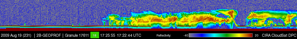
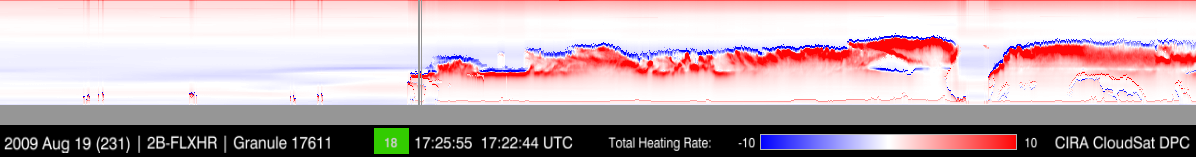
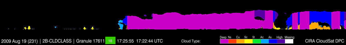
Example quicklooks from some of our products follow. In these cross sections, the horizontal axes are time (or
distance) and the vertical axes are height.
Radar reflectivity from 2B-GEOPROF
Radiative heating rate from 2B-FLXHR
Cloud classification from 2B-CLDCLASS
How to find product information
Details about our products can be found by using the Data Products pull-down menu at the top of this page, and
selecting the “Level” of the product you want to find out more about.
How to find data and place an order
There are several ways to find the data using this website. The easiest way to locate the Level 2 data you need is
to utilize the data ordering system, which allows you to search for data by either date, granule number, or
geographic location (coming soon). The first step is to click the “Orders” tab at the top of this screen, then
select “New Orders”. Login with your username and password, or if you don’t already have one, you can create a new
account from here.
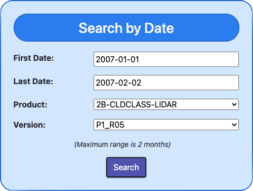
If you are interested in data from a certain date or range of dates, use the Search by Date tool. Enter a
start data and end date in the appropriate boxes (either using the calendar selection tool, or by typing a date
in the format YYYY-MM-DD), then select a product and version. In most cases, users will want to choose the
latest version.
An example of a data search in the date range 2007-01-01 through 2007-02-02 for the product 2B-CLDCLASS-LIDAR,
version P1_R05
If you already know the granule number containing the data you want to retrieve (perhaps from browsing through
Quicklooks images), use the Search by Granule tool. Enter a first and last
granule number, then select a product and version. In most cases, users will want to choose the latest version.
An example of a data search in the granule range 3607 through 3618 for the product 2B-GEOPROF, version P1_R05
A geographic selection tool is currently in development. This will allow you to select data relevant to
satellite overpasses of the geographic region you select. Until this tool is completed, please use the date or
granule selection tool instead.
Once search parameters are entered, select “Search”. Any granules matching your search parameters will be displayed
in a list, which may extend over multiple pages.
You might wish to note the granule numbers and use the Quicklook tool to
examine the data in these files.
If you are wish to download only some of the data returned by your search, either:
Select “Add to Cart” next to an individual granule of interest
Select the tick boxes next to multiple granules of interest, then select “Add Selected”,
When you are done, select “View cart” at the top of the page, and then “Submit Order” when you are satisfied with
your selections.
If you wish to download all of the data returned in the search, select “Add All” to add all granules to the
cart, then select “Submit Order”.
Versions and filenames
In brief, every CloudSat granule contains information in the filename that establishes:
the date and time period covered,
the epoch,
the product version and any fixes that have been applied since the major version release.
This information is also contained in metadata within the file.
In general, users will want to find granules that have the latest available major revision number (currently this is
R05), and also the latest fix (if any are present).
Information about versions and filenames can be found here.
Data format
Nearly all granule-level CloudSat data (Level 0 through 2C) are in HDF-EOS
format.
Gridded Level 3 data are in netCDF version 4
format.
Level 2D data are produced by external organizations, and may be in a variety of formats.
Software for reading data
We maintain a list of software tools that can be used to read CloudSat
data.
General Information about CloudSat
CloudSat's Cloud Profiling Radar
CloudSat, which launched from Vandenberg Airforce Base on April 28, 2006, is the satellite platform carrying the
Cloud Profiling Radar (CPR). The CPR is a 94 GHz (W-band) radar. Its relatively high frequency makes it sensitive to
the presence of the droplets and ice crystals that form clouds, and it is the first spaceborne radar to make
observations of this type. It also observes precipitation-sized particles, although the radar signal attenuates when
precipitation is too heavy.
The radar has a ground footprint of about 1.5 km, and a vertical resolution of 240 m (oversampled). A new profile
through the atmosphere is collected every 0.16 seconds.
CloudSat's orbit
CloudSat flies in a polar, sun-synchronous orbit, completing one revolution in approximately 99 min. This means
there are about 14.6 complete revolutions around the Earth per day. Since the sampling interval is 0.16 seconds, the
satellite moves 1.1 km relative to the Earth’s surface during this time.
Sun-synchronous means that the satellite always crosses the equator (from south to north) at the same local
solar time, which is approximately 13:30 (1:30 in the afternoon). This time is referred to as the local time of the
ascending node, or LTAN.
The data collected during one such revolution around the Earth is organized into one granule. The main
CloudSat products (Level 2B and 2C) are produced as granules, so you get one orbit of information per file.
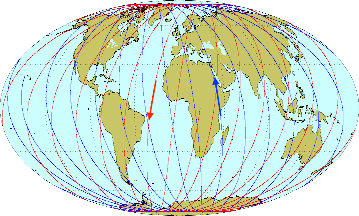
The ground track (you can view today’s here)
repeats every 16 days. The following figure shows the ground track for one particular 24 hour period. Blue
lines are ascending orbits, and red lines are descending. Note that the satellite would have likely passed over
completely different points on Earth if a different random day was chosen, but the pattern shown would still be the
same.
An example image showing CloudSat data passes for one particular 24-hour period
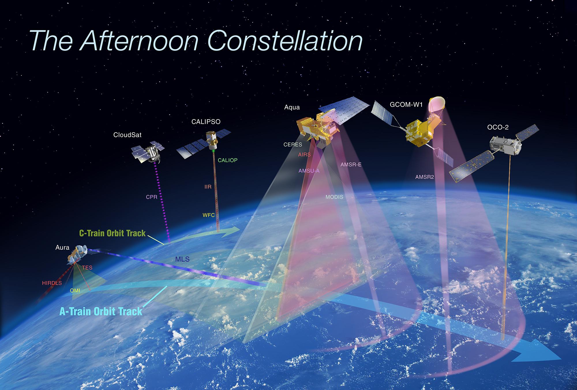
Formation flying
CloudSat has spent much of its life flying in formation with other satellites. During formation flying, the slice of
atmosphere that the CPR views overlaps with the field of view of instruments on other satellites.
CloudSat has a particularly close relationship with partner satellite CALIPSO and its CALIOP lidar. The two satellites launched on the
same rocket, and since they fly in formation, they can be used synergistically together to profile most hydrometeors
in the Earth’s atmosphere. In particular, CALIOP views many of the tenuous cirrus clouds that are below CPR’s
sensitivity, and CPR penetrates through deeper clouds where CALIOP loses signal.
CloudSat and CALIPSO flew in formation with the A-Train until February 2018.
In October 2018 the two satellites rejoined to form the C-Train. For more information on important dates in the life
of CloudSat, see the section “Important dates and things to keep in mind”.
An image showing "The Afternoon Constellation" (A-Train) [Source]
Some core references for CloudSat describing the mission and radar specifications:
Stephens, G. L., and Coauthors, 2008: CloudSat mission: Performance and early science after the first year of
operation. J. Geophys. Res., 113, D00A18, https://doi.org/10.1029/2008JD009982.
Tanelli, S., S. L. Durden, E. Im, K. S. Pak, D. G. Reinke, P. Partain, J. M. Haynes, and R. T. Marchand, 2008:
CloudSat’s cloud profiling radar after two years in orbit: Performance, calibration, and processing. IEEE Trans.
Geosci. Remote Sens., 46, 3560–3573, https://doi.org/10.1109/TGRS.2008.2002030.
Core references for most CloudSat data products are listed on the page dedicated to that product. You can find these
using the “Data Products” pulldown menu at the top of this page.
We encourage users to tell us about publications they have submitted that use CloudSat data. The publications list
can be found here.
CloudSat Epoch Information
Epoch 10
After a second reaction wheel anomaly on 26 August 2020 CloudSat returned to operation in December of 2021
in ACT-TWO (Attitude Control Through Two Wheel Operations) DO-Op (Daylight-Only Operations) mode, no longer
in formation with CALIPSO.
Start: 16 Dec 2021 (Day 350) 14:27:41 End: 19 September 2023 (Day 262) 15:26:30
Epoch 09
Starting on July 5th, 2019 and continuing through August 26th, 2020, the apparent height of the surface in
the radar profiles is not consistent with the Digital Elevation Map (DEM) that has been used with all
CloudSat operational products throughout the mission. The mismatch is a result of an error in the satellite
pointing or timing data or both. While still under investigation, the present the cause has not been
isolated. Rather than further delaying the release of these data, they are being released as-is with the
pointing/timing error. Fundamentally, this means there is a substantially larger uncertainty in the location
where the radar beam intersects the surface that may be as large as 10 km.
CloudSat exited the A-Train on February 22nd, 2018 after a reaction wheel anomaly.
Start: 3 May 2018 (Day 123) 07:25:00 End: End: 10 Oct 2018 (Day 283) 00:00:00
Epoch 06
Although CloudSat continues to only operate during the sunlit portion of the orbit, epoch 06 started when
CloudSat returned to the A-Train formation on May 15th, 2012.
Data products once again use MODIS and CALIPSO ancillary data although the overlap with CALIPSO is degraded
because fewer formation flying maneuvers are performed.
Start: 15 May 2012 (Day 136) 00:49:00 End: 12 Jan 2018 (Day 12) 15:15:56
Epoch 05
A battery anomaly on April 17th, 2011 caused the spacecraft to stop collecting data and lose formation with
the A-Train.
The radar was turned back on in November 2011 and now collects data only during the sunlit portion of the
orbit.
Epoch 05 represents this new operating paradigm.
In addition, the spacecraft remained outside of the A-Train formation so all data products were processed in
radar-only mode without MODIS or CALIPSO data.
The impact of the missing MODIS data on the CloudSat products is still being assessed and the combined
radar/lidar products (2B-GEOPROF-LIDAR, 2B-CLDCLASS-LIDAR, and 2B-FLXHR-LIDAR) are not available.
Start: 27 Oct 2011 (Day 300) 23:28:21 End: 15 May 2012 (Day 136) 00:49:00
Epoch 04
Marks the beginning of a period where the CPR pulse rate will be periodically reduced, or increased, to
manage the power draw on the battery (due to the reduced power margin as the battery ages).
The increased or reduced pulsing with induce a slight change in sensitivity.
The number of pulses can be found in the 1B-CPR field RayStatus_pulsesTx.
The pulse rate will likely continue to be adjusted, seasonally, for the duration of the mission.
Epoch 02 ended when a battery anomaly forced the CPR offline.
It was brought back into operations with a slightly reduced pulse rate that decreases the radar sensitivity
by approximately 0.25 dB.
Epoch 03 tags the modified operating parameters.
Start: 15 Jan 2010 (Day 15) 18:24:56 End: 15 Feb 2011 (Day 46) 18:06:30
Epoch 02
Increased specular reflection due to the nadir-pointing instrument caused an increase in ground clutter, so
the spacecraft orientation was changed again so that the CPR pointed 0.16 degrees in the forward
(along-track) direction.
Start: 15 Aug 2006 (Day 227) 20:56:31 End: 7 Dec 2009 (Day 341) 11:43:22
Epoch 01
The pointing error was corrected and the spacecraft was oriented so that the CPR pointed to nadir.
During the initial phase of the mission it was unknown that the CPR was pointing off-nadir 1.7021 degrees in
the forward (along-track) direction and 0.1314 degress to the right (across-track).