Current Epoch: Epoch 10
Start: 16 Dec 2021 (Day 350) 14:27:41 | End: Present
Active Release: R05
R04 products will be available until all R05 products have been released.
2B-GEOPROF
Product Availability: Full mission availability except for anomalies and maneuver data gaps
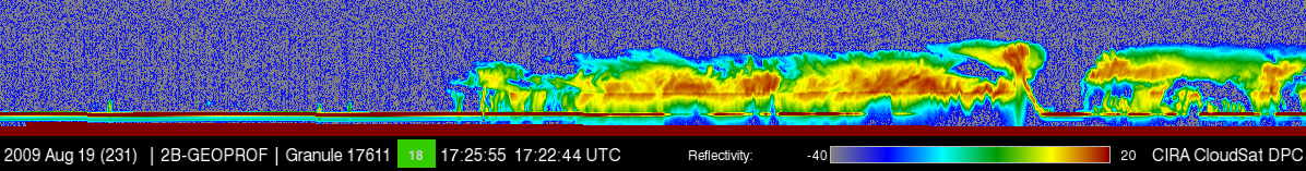
The 2B GEOPROF R04 product identifies those levels in the vertical column sampled by CloudSat that contain significant radar echo from hydrometeors (rather than noise or radar clutter) and provides an estimate of the radar reflectivity factor for each of these volumes. Also included in the GEOPROF product is an estimate of the expected gaseous absorption loss for the observed reflectivity (which depends on water vapor fields from ECMWF), the MODIS cloud fraction (from MOD35) associated with the radar surface foot print, and several other flags the indicates the homogeneity of the MODIS data, and quality of the CloudSat data. Details on the GEOPROF algorithms and structure of the HDF-EOS output files can be found in Marchand et al. (2008) and the Level 2 GEOPROF Product Process Description and Interface Control Document.
Primary Publication(s)
Process Description and Interface Control Document (PDICD)
E09 Data Issues (Updated January 30, 2023)2B-GEOPROF P1_R05 PDICD (Rev. 0) (Updated June 18, 2017)
Process Description and Interface Control Document (PDICD)
2B-FLXHR-LIDAR P_R04 PDICD (Updated June 28, 2007)Quality Statement (Updated May 1, 2007)
Data Issues (Updated April 30, 2007)
Algorithm Specifications (for latest R05)
Geolocation Fields
| Field | Type | Dimensions | Units | Valid Range | Missing | Missing Op. | Factor | Offset |
|---|---|---|---|---|---|---|---|---|
| Profile_time | FLOAT32 | nray | seconds | [0.0, 6000.0] | 1.0 | 0.0 | ||
| UTC_start | FLOAT32 | scalar | seconds | [0.0, 86400.0] | 1.0 | 0.0 | ||
| TAI_start | FLOAT64 | scalar | seconds | [0.0, 600000000.0] | 1.0 | 0.0 | ||
| Latitude | FLOAT32 | nray | degrees | [-90.0, 90.0] | 1.0 | 0.0 | ||
| Longitude | FLOAT32 | nray | degrees | [-180.0, 180.0] | 1.0 | 0.0 | ||
| Height | INT16 | nray,nbin | m | [-5000.0, 30000] | -9999 | == | 1.0 | 0.0 |
| Range_to_intercept | FLOAT32 | nray | km | [600.0, 800.0] | 1.0 | 0.0 | ||
| DEM_elevation | INT16 | nray | meters | [-9999.0, 8850] | 9999 | == | 1.0 | 0.0 |
| Vertical_binsize | FLOAT32 | scalar | m | -9999.0 | == | 1.0 | 0.0 | |
| Pitch_offset | FLOAT32 | scalar | degrees | [-90.0, 90.0] | 1.0 | 0.0 | ||
| Roll_offset | FLOAT32 | scalar | degrees | [-90.0, 90.0] | 1.0 | 0.0 |
Data Fields
| Field | Type | Dimensions | Units | Valid Range | Missing | Missing Op. | Factor | Offset |
|---|---|---|---|---|---|---|---|---|
| Data_quality | UINT8 | nray | -- | [0, 255] | 1.0 | 0.0 | ||
| Data_status | UINT16 | nray | -- | [0, 65535] | 1.0 | 0.0 | ||
| Data_targetID | UINT8 | nray | -- | [0, 255] | 1.0 | 0.0 | ||
| RayStatus_validity | UINT8 | nray | -- | [0, 255] | 1.0 | 0.0 | ||
| SurfaceHeightBin | INT8 | nray | [1, 125] | -1 | == | 1.0 | 0.0 | |
| SurfaceHeightBin_fraction | FLOAT32 | nray | none | 0.0 | 1.0 | 0.0 | ||
| CPR_Cloud_mask | INT8 | nray,nbin | [0, 40] | -9 | == | 1.0 | 0.0 | |
| Gaseous_Attenuation | INT16 | nray,nbin | dBZe | [0, 1000] | -9999 | == | 100.0 | 0.0 |
| Radar_Reflectivity | INT16 | nray,nbin | dBZe | [-4000.0, 5000] | -8888 | == | 100.0 | 0.0 |
| Sigma-Zero | INT16 | nray | dB*100 | [-1000.0, 4000] | -9999 | == | 1.0 | 0.0 |
| MODIS_cloud_flag | INT8 | nray | None | [0, 3] | 99 | == | 1.0 | 0.0 |
| MODIS_Cloud_Fraction | INT8 | nray | [0, 100] | -99 | == | 1.0 | 0.0 | |
| MODIS_scene_char | INT8 | nray | [0, 9] | -9 | == | 1.0 | 0.0 | |
| MODIS_scene_var | INT8 | nray | [0, 5] | -9 | == | 1.0 | 0.0 | |
| CPR_Echo_Top | INT8 | nray | [0, 5] | -9 | == | 1.0 | 0.0 | |
| sem_NoiseFloor | FLOAT32 | nray | 0.0 | == | 1.0 | 0.0 | ||
| sem_NoiseFloorVar | FLOAT32 | nray | 0.0 | == | 1.0 | 0.0 | ||
| sem_NoiseGate | INT8 | nray | 0 | == | 1.0 | 0.0 | ||
| Navigation_land_sea_flag | UINT8 | nray | -- | [1, 4] | 1.0 | 0.0 | ||
| Clutter_reduction_flag | INT8 | nray | 1.0 | 0.0 | ||||
| sem_MDSignal | FLOAT32 | nray | dBZe | [-35.0, -20.0] | 9999.0 | == | 1.0 | 0.0 |