Current Epoch: Epoch 10
Start: 16 Dec 2021 (Day 350) 14:27:41 | End: Present
Active Release: R05
R04 products will be available until all R05 products have been released.
2B-GEOPROF-LIDAR
Product Availability: Available during A-Train and C-Train Epochs except for anomalies and maneuver data gaps
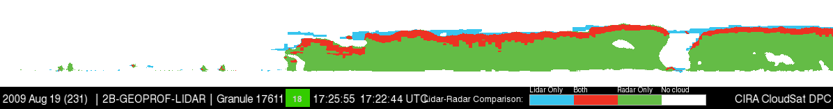
The NASA CloudSat cloud profiling radar (CPR) and the Calipso Cloud-Aerosol Lidar with Orthogonal Polarization (CALIOP) generally fly in close coordination with one another. 2B-Geoprof-lidar product indicates the fraction of each GeoProf radar volume which contains a lidar cloud detection (detected using 5 km or shorter along track averaging), as well as a variety of summary values (such as the height of the highest detected cloud). Details on the Geoprof-lidar can be found in Mace and Zhang (2014) and the Level 2 GEOPROF-LIDAR Product Process Description and Interface Control Document.
Primary Publication(s)
Process Description and Interface Control Document (PDICD)
2B-GEOPROF-LIDAR P2_R05 Data Issues (Updated August 8, 2023)E09 Data Issues (Updated January 30, 2023)
Process Description and Interface Control Document (PDICD)
2B-GEOPROF-LIDAR P2_R04 PDICD (Updated June 4, 2007)Algorithm Specifications (for latest R05)
Geolocation Fields
| Field | Type | Dimensions | Units | Valid Range | Missing | Missing Op. | Factor | Offset |
|---|---|---|---|---|---|---|---|---|
| Profile_time | FLOAT32 | nray | seconds | [0.0, 6000.0] | 1.0 | 0.0 | ||
| UTC_start | FLOAT32 | scalar | seconds | [0.0, 86400.0] | 1.0 | 0.0 | ||
| TAI_start | FLOAT64 | scalar | seconds | [0.0, 600000000.0] | 1.0 | 0.0 | ||
| Latitude | FLOAT32 | nray | degrees | [-90.0, 90.0] | 1.0 | 0.0 | ||
| Longitude | FLOAT32 | nray | degrees | [-180.0, 180.0] | 1.0 | 0.0 | ||
| Height | INT16 | nray,nbin | m | [-5000.0, 30000] | -9999 | == | 1.0 | 0.0 |
| Range_to_intercept | FLOAT32 | nray | km | [600.0, 800.0] | 1.0 | 0.0 | ||
| DEM_elevation | INT16 | nray | meters | [-9999.0, 8850] | 9999 | == | 1.0 | 0.0 |
| Vertical_binsize | FLOAT32 | scalar | m | -9999.0 | == | 1.0 | 0.0 | |
| Pitch_offset | FLOAT32 | scalar | degrees | [-90.0, 90.0] | 1.0 | 0.0 | ||
| Roll_offset | FLOAT32 | scalar | degrees | [-90.0, 90.0] | 1.0 | 0.0 |
Data Fields
| Field | Type | Dimensions | Units | Valid Range | Missing | Missing Op. | Factor | Offset |
|---|---|---|---|---|---|---|---|---|
| Data_quality | UINT8 | nray | -- | [0, 255] | 1.0 | 0.0 | ||
| Data_status | UINT16 | nray | -- | [0, 65535] | 1.0 | 0.0 | ||
| Data_targetID | UINT8 | nray | -- | [0, 255] | 1.0 | 0.0 | ||
| RayStatus_validity | UINT8 | nray | -- | [0, 255] | 1.0 | 0.0 | ||
| Navigation_land_sea_flag | UINT8 | nray | -- | [1, 4] | 1.0 | 0.0 | ||
| CloudFraction | INT8 | nray,nbin | [0, 100] | -9 | == | 1.0 | 0.0 | |
| VFMHistogram | INT8 | nray,nbin,nvfmavg | [0, 50] | -9 | == | 1.0 | 0.0 | |
| UncertaintyCF | INT8 | nray,nbin | [0, 100] | -9 | == | 1.0 | 0.0 | |
| CloudLayers | INT8 | nray | [0, 5] | -9 | == | 1.0 | 0.0 | |
| LayerBase | INT16 | nray,ncloud | m | [0, 25000] | -99 | == | 1.0 | 0.0 |
| LayerTop | INT16 | nray,ncloud | m | [0, 25000] | -99 | == | 1.0 | 0.0 |
| FlagBase | INT8 | nray,ncloud | [0, 3] | -9 | == | 1.0 | 0.0 | |
| FlagTop | INT8 | nray,ncloud | [0, 3] | -9 | == | 1.0 | 0.0 | |
| DistanceAvg | INT16 | nray,nbin | m | [0, 10000] | -99 | == | 1.0 | 0.0 |
| NumLidar | INT8 | nray,nbin | [0, 50] | -9 | == | 1.0 | 0.0 |