Current Epoch: Epoch 10
Start: 16 Dec 2021 (Day 350) 14:27:41 | End: Present
Active Release: R05
R04 products will be available until all R05 products have been released.
2C-PRECIP-COLUMN
Product Availability: Full mission availability except for anomalies and maneuver data gaps
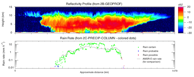
The objective of the algorithm is to determine the presence of surface precipitation, and quantify the intensity, based on CloudSat Profiling Radar (CPR) observations. The algorithm makes use of the radar reflectivity near the surface of the earth and an estimate of path integrated attenuation (PIA) determined from the surface reflection characteristics to determine precipitation occurrence (over all surface types) and intensity (over water surfaces).
Changes/Updates in Algorithm Version P_R05
- This product now primarily focuses on precipitation incidence. A side effect is that some variables have been renamed; Precip_rate becomes Diagnostic_precip_rate, and so on.
- The convective and stratiform retrievals have been rebuilt from the ground-up, and now share a largely unified code base. New lookup tables of precipitation rate and path integrated attenuation have been built using Robin Hogan’s Time-Dependent Two-Stream model of multiple scattering (Hogan and Battaglia 2008). Improvements have also been made that should result in better simulation of the CloudSat radar’s antenna beam pattern.
- A new method of determining PIA, using local observations of the clear sky surface, is used when available. This significantly reduces uncertainty in PIA, especially over the ocean surface (see Section 2.1.1).
- PIA is now reported everywhere it can be calculated, including for non-raining profiles. It is reported (experimentally) over non-water surfaces.
- Various bug fixes.
(For more details, see the 2C-PRECIP-COLUMN P_R05 Process Description and Interface Control Document (PDICD).)
Primary Publication(s)
Process Description and Interface Control Document (PDICD)
2C-PRECIP-COLUMN P1_R05 PDICD (Rev. 1) (Updated January 26, 2018)E09 Data Issues (Updated January 30, 2023)
Process Description and Interface Control Document (PDICD)
2C-PRECIP-COLUMN P2_R04 PDICD (Updated January 24, 2013)Algorithm Specifications (for latest R05)
Geolocation Fields
| Field | Type | Dimensions | Units | Valid Range | Missing | Missing Op. | Factor | Offset |
|---|---|---|---|---|---|---|---|---|
| Profile_time | FLOAT32 | nray | seconds | [0.0, 6000.0] | 1.0 | 0.0 | ||
| UTC_start | FLOAT32 | scalar | seconds | [0.0, 86400.0] | 1.0 | 0.0 | ||
| TAI_start | FLOAT64 | scalar | seconds | [0.0, 600000000.0] | 1.0 | 0.0 | ||
| Latitude | FLOAT32 | nray | degrees | [-90.0, 90.0] | 1.0 | 0.0 | ||
| Longitude | FLOAT32 | nray | degrees | [-180.0, 180.0] | 1.0 | 0.0 | ||
| DEM_elevation | INT16 | nray | meters | [-9999.0, 8850] | 9999 | == | 1.0 | 0.0 |
Data Fields
| Field | Type | Dimensions | Units | Valid Range | Missing | Missing Op. | Factor | Offset |
|---|---|---|---|---|---|---|---|---|
| Data_quality | UINT8 | nray | -- | [0, 255] | 1.0 | 0.0 | ||
| Data_status | UINT16 | nray | -- | [0, 65535] | 1.0 | 0.0 | ||
| Data_targetID | UINT8 | nray | -- | [0, 255] | 1.0 | 0.0 | ||
| RayStatus_validity | UINT8 | nray | -- | [0, 255] | 1.0 | 0.0 | ||
| Navigation_land_sea_flag | UINT8 | nray | -- | [1, 4] | 1.0 | 0.0 | ||
| Precip_flag | INT8 | nray | [0, 9] | 1.0 | 0.0 | |||
| Status_flag | INT8 | nray | [0, 21] | 1.0 | 0.0 | |||
| Conv_strat_flag | INT16 | nray | [-3.0, 3] | -1000 | == | 1.0 | 0.0 | |
| PIA_hydrometeor | FLOAT32 | nray | dB | [-100.0, 100.0] | -1000.0 | == | 1.0 | 0.0 |
| PIA_near_surface | FLOAT32 | nray | dB | [-100.0, 100.0] | -1000.0 | == | 1.0 | 0.0 |
| PIA_uncertainty | FLOAT32 | nray | dB | [0.0, 100.0] | -1000.0 | == | 1.0 | 0.0 |
| Sigma_zero | FLOAT32 | nray | dB | [-100.0, 100.0] | -1000.0 | == | 1.0 | 0.0 |
| Near_surface_reflectivity | FLOAT32 | nray | dBZe | [-100.0, 100.0] | -1000.0 | 1.0 | 0.0 | |
| Frozen_precip_height | FLOAT32 | nray | km | [0.0, 20.0] | -1000.0 | == | 1.0 | 0.0 |
| Rain_top_height | FLOAT32 | nray | km | [0.0, 20.0] | -1000.0 | == | 1.0 | 0.0 |
| Melted_fraction | FLOAT32 | nray | [0.0, 1.0] | -1000.0 | == | 1.0 | 0.0 | |
| Lowest_sig_layer_top | FLOAT32 | nray | km | [0.0, 20.0] | -1000.0 | == | 1.0 | 0.0 |
| Highest_sig_layer_top | FLOAT32 | nray | km | [0.0, 20.0] | -1000.0 | == | 1.0 | 0.0 |
| Cloud_flag | INT8 | nray | [0, 9] | 1.0 | 0.0 | |||
| Surface_type | INT8 | nray | [0, 9] | 1.0 | 0.0 | |||
| Freezing_level | FLOAT32 | nray | km | [0.0, 10.0] | -1000.0 | == | 1.0 | 0.0 |
| SST | FLOAT32 | nray | deg C | [-100.0, 100.0] | -1000.0 | == | 1.0 | 0.0 |
| Surface_wind | FLOAT32 | nray | m/s | [0.0, 200.0] | -1000.0 | == | 1.0 | 0.0 |
| Diagnostic_precip_rate | FLOAT32 | nray | mm/h | [-40.0, 40.0] | -1000.0 | == | 1.0 | 0.0 |
| Diagnostic_precip_rate_min | FLOAT32 | nray | mm/h | [-40.0, 40.0] | -1000.0 | == | 1.0 | 0.0 |
| Diagnostic_precip_rate_max | FLOAT32 | nray | mm/h | [-40.0, 40.0] | -1000.0 | == | 1.0 | 0.0 |
| Diagnostic_precip_rate_no_ms | FLOAT32 | nray | mm/h | [-40.0, 40.0] | -1000.0 | == | 1.0 | 0.0 |
| Diagnostic_retrieval_info | INT8 | nray | [0, 51] | 1.0 | 0.0 | |||
| Diagnostic_retrieval_type | INT8 | nray | [0, 9] | 1.0 | 0.0 | |||
| Diagnostic_SRT | INT8 | nray | [0, 9] | 1.0 | 0.0 | |||
| Diagnostic_PIA_method | INT8 | nray | [1, 9] | 1.0 | 0.0 | |||
| Diagnostic_PIA_hydrometeor_ws | FLOAT32 | nray | dB | [-100.0, 100.0] | -1000.0 | == | 1.0 | 0.0 |
| Diagnostic_PIA_uncertainty_ws | FLOAT32 | nray | dB | [0.0, 100.0] | -1000.0 | == | 1.0 | 0.0 |
| Experimental_land_PIA | FLOAT32 | nray | dB | [-100.0, 100.0] | -1000.0 | == | 1.0 | 0.0 |
| Experimental_land_PIA_uncertainty | FLOAT32 | nray | dB | [0.0, 100.0] | -1000.0 | == | 1.0 | 0.0 |
| unused | INT8 | y,x | - | 1.0 | 0.0 |