Current Epoch: Epoch 10
Start: 16 Dec 2021 (Day 350) 14:27:41 | End: Present
Active Release: R05
R04 products will be available until all R05 products have been released.
2B-CLDCLASS
Product Availability: Full mission availability except for anomalies and maneuver data gaps
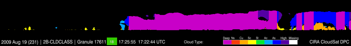
Classifying cloud type is an important task for global cloud climatology studies. Different types of clouds are governed by different cloud dynamical processes and have different microphysical properties, which can result in quite different cloud radiative forcings. Because cloud type corresponds to specific cloud physical properties, cloud classification is also needed to apply other algorithms to derive quantitative cloud content and radiative data. 2B-CLDCLASS classifies clouds into either stratus (St), stratus (Sc), cumulus (Cu, including cumulus congestus), nimbostratus (Ns), altocumulus (Ac), altostratus (As), deep convective (cumulonimbus), or high (cirrus and cirrostratus) clouds, based on different rules for hydrometeor vertical and horizontal scales, the maximum Ze measured by the CPR, indications of precipitation, and ancillary data including ECMWF predicted temperature profiles and surface topography height.
Primary Publication(s)
Process Description and Interface Control Document (PDICD)
PDICD (Rev. 1) (Updated May 17, 2019)E09 Data Issues (Updated January 30, 2023)
Algorithm Specifications (for latest R05)
Geolocation Fields
| Field | Type | Dimensions | Units | Valid Range | Missing | Missing Op. | Factor | Offset |
|---|---|---|---|---|---|---|---|---|
| Profile_time | FLOAT32 | nray | seconds | [0.0, 6000.0] | 1.0 | 0.0 | ||
| UTC_start | FLOAT32 | scalar | seconds | [0.0, 86400.0] | 1.0 | 0.0 | ||
| TAI_start | FLOAT64 | scalar | seconds | [0.0, 600000000.0] | 1.0 | 0.0 | ||
| Latitude | FLOAT32 | nray | degrees | [-90.0, 90.0] | 1.0 | 0.0 | ||
| Longitude | FLOAT32 | nray | degrees | [-180.0, 180.0] | 1.0 | 0.0 | ||
| Height | INT16 | nray,nbin | m | [-5000.0, 30000] | -9999 | == | 1.0 | 0.0 |
| Range_to_intercept | FLOAT32 | nray | km | [600.0, 800.0] | 1.0 | 0.0 | ||
| DEM_elevation | INT16 | nray | meters | [-9999.0, 8850] | 9999 | == | 1.0 | 0.0 |
| Vertical_binsize | FLOAT32 | scalar | m | -9999.0 | == | 1.0 | 0.0 | |
| Pitch_offset | FLOAT32 | scalar | degrees | [-90.0, 90.0] | 1.0 | 0.0 | ||
| Roll_offset | FLOAT32 | scalar | degrees | [-90.0, 90.0] | 1.0 | 0.0 |
Data Fields
| Field | Type | Dimensions | Units | Valid Range | Missing | Missing Op. | Factor | Offset |
|---|---|---|---|---|---|---|---|---|
| Data_quality | UINT8 | nray | -- | [0, 255] | 1.0 | 0.0 | ||
| Data_status | UINT16 | nray | -- | [0, 65535] | 1.0 | 0.0 | ||
| Data_targetID | UINT8 | nray | -- | [0, 255] | 1.0 | 0.0 | ||
| RayStatus_validity | UINT8 | nray | -- | [0, 255] | 1.0 | 0.0 | ||
| Navigation_land_sea_flag | UINT8 | nray | -- | [1, 4] | 1.0 | 0.0 | ||
| Precip_flag | INT8 | nray | [0, 9] | 1.0 | 0.0 | |||
| SST | FLOAT32 | nray | deg C | [-100.0, 100.0] | -1000.0 | == | 1.0 | 0.0 |
| Surface_wind | FLOAT32 | nray | m/s | [0.0, 200.0] | -1000.0 | == | 1.0 | 0.0 |
| cloud_scenario | INT16 | nray,nbin | none | [0, 32767] | 1.0 | 0.0 | ||
| CloudLayer | INT16 | nray | none | [0, 32767] | 1.0 | 0.0 | ||
| CloudLayerBase | FLOAT32 | nray,Ncloud | km | [0.0, 20.0] | 1.0 | 0.0 | ||
| CloudLayerTop | FLOAT32 | nray,Ncloud | km | [0.0, 30.0] | 1.0 | 0.0 | ||
| CloudLayerType | INT16 | nray,Ncloud | none | [0, 9] | 1.0 | 0.0 |